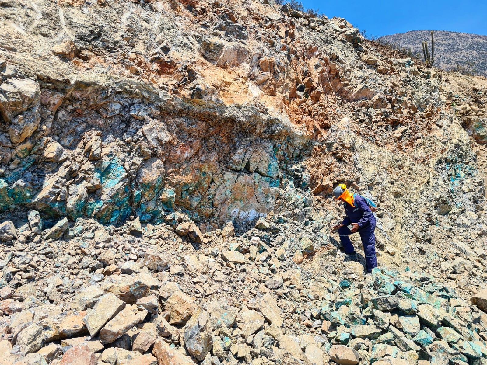
Raquel – Magdalena Mining Project
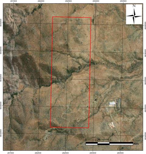
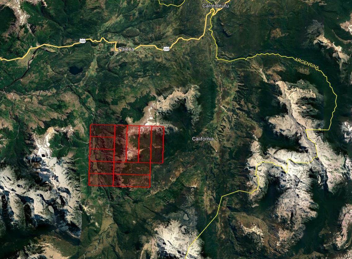
Provincia de Petorca, Valparaíso, Chile
ADVANCED EXPLORATION
USD 800KAcquisition +8
18 Aug 2026
View opportunity
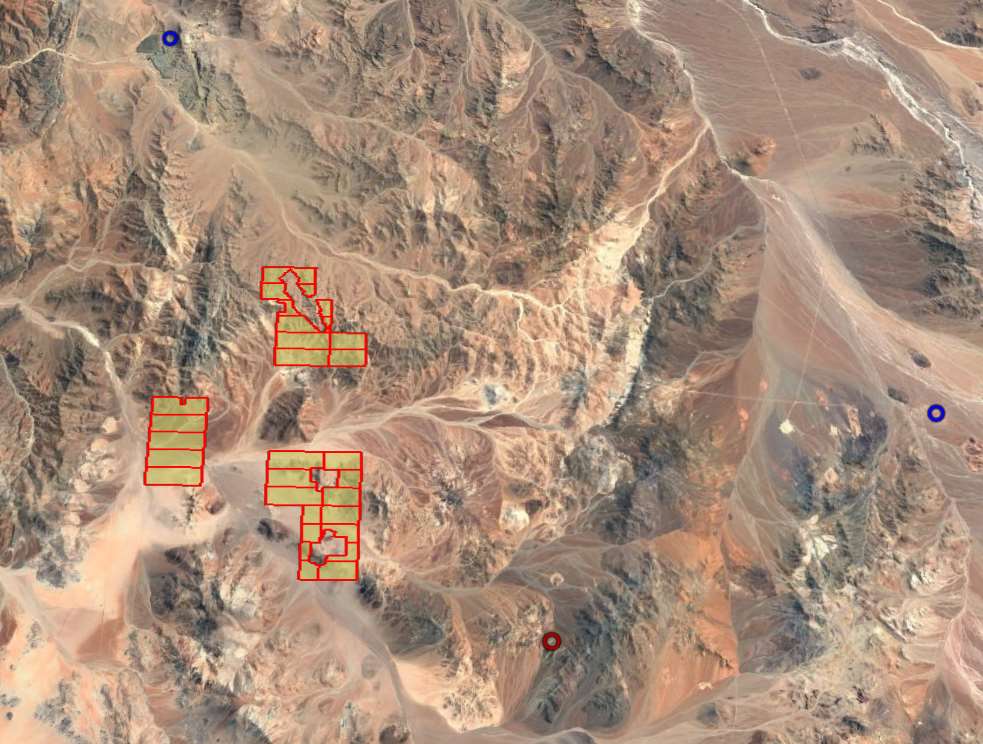
Prospecto Molino es un yacimiento IOCG de cobre-oro en etapa de exploración básica ubicado en la Región de Atacama, emplazado en granitoides del Jurásico tardío a Cretácico intruidos en volcánicos, carbonatos y rocas paleozoicas a lo largo del Sistema de Falla de Atacama. La mineralización se presenta en vetas hospedadas en plutones, asociadas a diques dioríticos o andesíticos, con assemblages que incluyen magnetita, cuarzo, turmalina, calcopirita, oro, especularita, crisocola y atacamita. Los cuerpos mineralizados, inferidos a partir de laboreos históricos, corresponden a clavos lenticulares de manteo subvertical con potencias de hasta 4 metros y corridas de hasta 30 metros.
Prospecto IOCG Cu-Au en exploración básica con vetas de hasta 4 m de potencia en plutones jurásicos-cretácicos del Sistema de Falla de Atacama
Prospecto IOCG de cobre-oro en exploración básica, Región de Atacama
Chilean concession: two types can coexist (exploration / exploitation).
| # | Name | Type | Area |
|---|---|---|---|
| 1 | BERTA 8C | Exploration | 200 ha |
Linked by polygon (different name in ENAMI: «BERTA 8C») In the Sernageomin mining cadastre: «BERTA 8D» · rol 031019060 · the polygons overlap by 95% or more in both directions Source: Sernageomin mining cadastre as of 25 Oct 2026 | |||
| 2 | BERTA 13B | Exploration | 100 ha |
Linked by polygon (different name in ENAMI: «BERTA 13B») In the Sernageomin mining cadastre: «BERTA 13C» · rol 031018670 · the polygons overlap by 95% or more in both directions Source: Sernageomin mining cadastre as of 25 Oct 2026 | |||
| 3 | BERTA 14B | Exploration | 200 ha |
Linked by polygon (different name in ENAMI: «BERTA 14B») In the Sernageomin mining cadastre: «BERTA 14C» · rol 031018669 · the polygons overlap by 95% or more in both directions Source: Sernageomin mining cadastre as of 25 Oct 2026 | |||
| 4 | BERTA 15B | Exploration | 200 ha |
Linked by polygon (different name in ENAMI: «BERTA 15B») In the Sernageomin mining cadastre: «BERTA 15C» · rol 031018668 · the polygons overlap by 95% or more in both directions Source: Sernageomin mining cadastre as of 25 Oct 2026 | |||
| 5 | BERTA 16B | Exploration | 200 ha |
Linked by polygon (different name in ENAMI: «BERTA 16B») In the Sernageomin mining cadastre: «BERTA 16C» · rol 031018667 · the polygons overlap by 95% or more in both directions Source: Sernageomin mining cadastre as of 25 Oct 2026 | |||
| 6 | BERTA 1C | Exploration | 200 ha |
Linked by polygon (different name in ENAMI: «BERTA 1C») In the Sernageomin mining cadastre: «BERTA 1D» · rol 031019065 · the polygons overlap by 95% or more in both directions Source: Sernageomin mining cadastre as of 25 Oct 2026 | |||
| 7 | BERTA 2C | Exploration | 200 ha |
Linked by polygon (different name in ENAMI: «BERTA 2C») In the Sernageomin mining cadastre: «BERTA 2D» · rol 031019066 · the polygons overlap by 95% or more in both directions Source: Sernageomin mining cadastre as of 25 Oct 2026 | |||
| 8 | BERTA 3C | Exploration | 300 ha |
Linked by polygon (different name in ENAMI: «BERTA 3C») In the Sernageomin mining cadastre: «BERTA 3D» · rol 031019067 · the polygons overlap by 95% or more in both directions Source: Sernageomin mining cadastre as of 25 Oct 2026 | |||
| 9 | BERTA 4C | Exploration | 300 ha |
Linked by polygon (different name in ENAMI: «BERTA 4C») In the Sernageomin mining cadastre: «BERTA 4D» · rol 031019068 · the polygons overlap by 95% or more in both directions Source: Sernageomin mining cadastre as of 25 Oct 2026 | |||
| 10 | BERTA 5C | Exploration | 300 ha |
Linked by polygon (different name in ENAMI: «BERTA 5C») In the Sernageomin mining cadastre: «BERTA 5D» · rol 031019069 · the polygons overlap by 95% or more in both directions Source: Sernageomin mining cadastre as of 25 Oct 2026 | |||
| 11 | BERTA 6C | Exploration | 300 ha |
Linked by polygon (different name in ENAMI: «BERTA 6C») In the Sernageomin mining cadastre: «BERTA 6D» · rol 031019070 · the polygons overlap by 95% or more in both directions Source: Sernageomin mining cadastre as of 25 Oct 2026 | |||
| 12 | BERTA 7C | Exploration | 200 ha |
Linked by polygon (different name in ENAMI: «BERTA 7C») In the Sernageomin mining cadastre: «BERTA 7D» · rol 031019059 · the polygons overlap by 95% or more in both directions Source: Sernageomin mining cadastre as of 25 Oct 2026 | |||
| 13 | BERTA 12B | Exploration | 200 ha |
Conflicting sources ELIMINATED in Sernageomin's register of extinguished concessions (record edited 16 Jul 2026; read 3 Oct 2026); the current cadastre published it until 10 Aug 2026 and the Official Mining Bulletin (BOM) published its extension (CVE-2864062, 2 Sep 2026). We do not state whether it is in force or extinguished. Check with the Registry of Mines or the court file · Sources: Sernageomin register of extinguished concessions (record edited 16 Jul 2026; read 3 Oct 2026) · current Sernageomin cadastre until 10 Aug 2026 · BOM 2 Sep 2026 | |||
| 14 | MOLINO 19º 1-30 | Exploitation | 288 ha |
| 15 | MOLINO 5º 1-30 | Exploitation | 300 ha |
| 16 | MOLINO 20º 1-30 | Exploitation | 300 ha |
| 17 | MOLINO 21º 1-30 | Exploitation | 300 ha |
| 18 | MOLINO 36º 1-10 | Exploitation | 91 ha |
| 19 | MOLINO 24º 1-20 | Exploitation | 200 ha |
| 20 | MOLINO 37º 1-20 | Exploitation | 194 ha |
| 21 | MOLINO 13º 1-28 | Exploitation | 242 ha |
| 22 | MOLINO 15º 1-10 | Exploitation | 100 ha |
Linked by polygon (different name in ENAMI: «MOLINO 15º 1-10») In the Sernageomin mining cadastre: «MOLINO 15 1/30» · rol 031012340 · the polygons overlap by 95% or more in both directions Source: Sernageomin mining cadastre as of 25 Oct 2026 | |||
| 23 | MOLINO 6º 1-30 | Exploitation | 300 ha |
| 24 | MOLINO 12º 1-30 | Exploitation | 293 ha |
| 25 | MOLINO 14º 1-30 | Exploitation | 294 ha |
| 26 | MOLINO 25º 1-20 | Exploitation | 200 ha |
| 27 | MOLINO 31º 1-20 | Exploitation | 200 ha |
| 28 | MOLINO 32º 1-12 | Exploitation | 120 ha |
| 29 | MOLINO 33º 1-20 | Exploitation | 184 ha |
Partial link with the cadastre The ENAMI polygon covers 100% of the concession rol 031012152 (184 ha). The legal area from the cadastre is shown. Source: Sernageomin mining cadastre as of 25 Oct 2026 · ENAMI layer as of 12 Aug 2026 | |||
| 30 | MOLINO 34º 1-20 | Exploitation | 200 ha |
| 31 | MOLINO 18º 1-10 | Exploitation | 93 ha |
| 32 | MOLINO 2º ALFA 1-17 | Exploitation | 140 ha |
ENAMI lists it as an exploration concession In the Sernageomin mining cadastre it is an exploitation concession, rol 031012226. The cadastre prevails. Source: Sernageomin mining cadastre as of 25 Oct 2026 · ENAMI layer as of 12 Aug 2026 | |||
| 33 | BERTA 10B | Exploration | 200 ha |
Linked by polygon (different name in ENAMI: «BERTA 10B») In the Sernageomin mining cadastre: «BERTA 10C» · rol 031018652 · the polygons overlap by 95% or more in both directions Source: Sernageomin mining cadastre as of 25 Oct 2026 | |||
| 34 | MOLINO 16º 1-10 | Exploitation | 95 ha |
| 35 | MOLINO 22º 1-30 | Exploitation | 300 ha |
| 36 | MOLINO 1º 1-30 | Exploitation | 235 ha |
| 37 | MOLINO 35º 1-16 | Exploitation | 138 ha |
| 38 | BERTA 11B | Exploration | 200 ha |
Linked by polygon (different name in ENAMI: «BERTA 11B») In the Sernageomin mining cadastre: «BERTA 11C» · rol 031018672 · the polygons overlap by 95% or more in both directions Source: Sernageomin mining cadastre as of 25 Oct 2026 ENAMI lists it as an exploitation concession In the Sernageomin mining cadastre it is an exploration concession, rol 031018672. The cadastre prevails. Source: Sernageomin mining cadastre as of 25 Oct 2026 · ENAMI layer as of 12 Aug 2026 | |||
| 39 | MOLINO 4º ALFA 1-24 | Exploitation | 195 ha |
| 40 | MOLINO 4º BETA 1-5 | Exploitation | 36 ha |
ENAMI lists it as an exploration concession In the Sernageomin mining cadastre it is an exploitation concession, rol 031012231. The cadastre prevails. Source: Sernageomin mining cadastre as of 25 Oct 2026 · ENAMI layer as of 12 Aug 2026 | |||
| 41 | MOLINO 23º 1-30 | Exploitation | 300 ha |
| 42 | MOLINO 2º BETA 1-8 | Exploitation | 54 ha |
ENAMI lists it as an exploration concession In the Sernageomin mining cadastre it is an exploitation concession, rol 031012227. The cadastre prevails. Source: Sernageomin mining cadastre as of 25 Oct 2026 · ENAMI layer as of 12 Aug 2026 | |||
| 43 | MOLINO 3º ALFA 1-11 | Exploitation | 71 ha |
| 44 | MOLINO 3º BETA 1-10 | Exploitation | 70 ha |
| 45 | MOLINO 17º 1-5 | Exploitation | 50 ha |
| Total: 45 concessions | 8,883 ha | ||
Linked by polygon (different name in ENAMI: «BERTA 8C»)
In the Sernageomin mining cadastre: «BERTA 8D» · rol 031019060 · the polygons overlap by 95% or more in both directions
Source: Sernageomin mining cadastre as of 25 Oct 2026
Linked by polygon (different name in ENAMI: «BERTA 13B»)
In the Sernageomin mining cadastre: «BERTA 13C» · rol 031018670 · the polygons overlap by 95% or more in both directions
Source: Sernageomin mining cadastre as of 25 Oct 2026
Linked by polygon (different name in ENAMI: «BERTA 14B»)
In the Sernageomin mining cadastre: «BERTA 14C» · rol 031018669 · the polygons overlap by 95% or more in both directions
Source: Sernageomin mining cadastre as of 25 Oct 2026
Linked by polygon (different name in ENAMI: «BERTA 15B»)
In the Sernageomin mining cadastre: «BERTA 15C» · rol 031018668 · the polygons overlap by 95% or more in both directions
Source: Sernageomin mining cadastre as of 25 Oct 2026
Linked by polygon (different name in ENAMI: «BERTA 16B»)
In the Sernageomin mining cadastre: «BERTA 16C» · rol 031018667 · the polygons overlap by 95% or more in both directions
Source: Sernageomin mining cadastre as of 25 Oct 2026
Linked by polygon (different name in ENAMI: «BERTA 1C»)
In the Sernageomin mining cadastre: «BERTA 1D» · rol 031019065 · the polygons overlap by 95% or more in both directions
Source: Sernageomin mining cadastre as of 25 Oct 2026
Linked by polygon (different name in ENAMI: «BERTA 2C»)
In the Sernageomin mining cadastre: «BERTA 2D» · rol 031019066 · the polygons overlap by 95% or more in both directions
Source: Sernageomin mining cadastre as of 25 Oct 2026
Linked by polygon (different name in ENAMI: «BERTA 3C»)
In the Sernageomin mining cadastre: «BERTA 3D» · rol 031019067 · the polygons overlap by 95% or more in both directions
Source: Sernageomin mining cadastre as of 25 Oct 2026
Linked by polygon (different name in ENAMI: «BERTA 4C»)
In the Sernageomin mining cadastre: «BERTA 4D» · rol 031019068 · the polygons overlap by 95% or more in both directions
Source: Sernageomin mining cadastre as of 25 Oct 2026
Linked by polygon (different name in ENAMI: «BERTA 5C»)
In the Sernageomin mining cadastre: «BERTA 5D» · rol 031019069 · the polygons overlap by 95% or more in both directions
Source: Sernageomin mining cadastre as of 25 Oct 2026
Linked by polygon (different name in ENAMI: «BERTA 6C»)
In the Sernageomin mining cadastre: «BERTA 6D» · rol 031019070 · the polygons overlap by 95% or more in both directions
Source: Sernageomin mining cadastre as of 25 Oct 2026
Linked by polygon (different name in ENAMI: «BERTA 7C»)
In the Sernageomin mining cadastre: «BERTA 7D» · rol 031019059 · the polygons overlap by 95% or more in both directions
Source: Sernageomin mining cadastre as of 25 Oct 2026
Conflicting sources
ELIMINATED in Sernageomin's register of extinguished concessions (record edited 16 Jul 2026; read 3 Oct 2026); the current cadastre published it until 10 Aug 2026 and the Official Mining Bulletin (BOM) published its extension (CVE-2864062, 2 Sep 2026). We do not state whether it is in force or extinguished.
Check with the Registry of Mines or the court file · Sources: Sernageomin register of extinguished concessions (record edited 16 Jul 2026; read 3 Oct 2026) · current Sernageomin cadastre until 10 Aug 2026 · BOM 2 Sep 2026
Linked by polygon (different name in ENAMI: «MOLINO 15º 1-10»)
In the Sernageomin mining cadastre: «MOLINO 15 1/30» · rol 031012340 · the polygons overlap by 95% or more in both directions
Source: Sernageomin mining cadastre as of 25 Oct 2026
Partial link with the cadastre
The ENAMI polygon covers 100% of the concession rol 031012152 (184 ha). The legal area from the cadastre is shown.
Source: Sernageomin mining cadastre as of 25 Oct 2026 · ENAMI layer as of 12 Aug 2026
ENAMI lists it as an exploration concession
In the Sernageomin mining cadastre it is an exploitation concession, rol 031012226. The cadastre prevails.
Source: Sernageomin mining cadastre as of 25 Oct 2026 · ENAMI layer as of 12 Aug 2026
Linked by polygon (different name in ENAMI: «BERTA 10B»)
In the Sernageomin mining cadastre: «BERTA 10C» · rol 031018652 · the polygons overlap by 95% or more in both directions
Source: Sernageomin mining cadastre as of 25 Oct 2026
Linked by polygon (different name in ENAMI: «BERTA 11B»)
In the Sernageomin mining cadastre: «BERTA 11C» · rol 031018672 · the polygons overlap by 95% or more in both directions
Source: Sernageomin mining cadastre as of 25 Oct 2026
ENAMI lists it as an exploitation concession
In the Sernageomin mining cadastre it is an exploration concession, rol 031018672. The cadastre prevails.
Source: Sernageomin mining cadastre as of 25 Oct 2026 · ENAMI layer as of 12 Aug 2026
ENAMI lists it as an exploration concession
In the Sernageomin mining cadastre it is an exploitation concession, rol 031012231. The cadastre prevails.
Source: Sernageomin mining cadastre as of 25 Oct 2026 · ENAMI layer as of 12 Aug 2026
ENAMI lists it as an exploration concession
In the Sernageomin mining cadastre it is an exploitation concession, rol 031012227. The cadastre prevails.
Source: Sernageomin mining cadastre as of 25 Oct 2026 · ENAMI layer as of 12 Aug 2026
Areas: Sernageomin mining cadastre as of 25 Oct 2026 unless noted
Information provided by the seller. Not independently verified by Mercado Minero except where indicated. This is not investment advice.